《学会学习和思考之地球科学》设计

Learning How to Learn and Think: Geologic Reasoning Concept Mapping Workshop

Beijing Normal University
September 11-22, 2017

Kip Ault, Ph.D., Professor Emeritus
Lewis & Clark Graduate School of Education and Counseling
Portland, Oregon
USA
www.darwinianwhimsy.com

1. Aims:

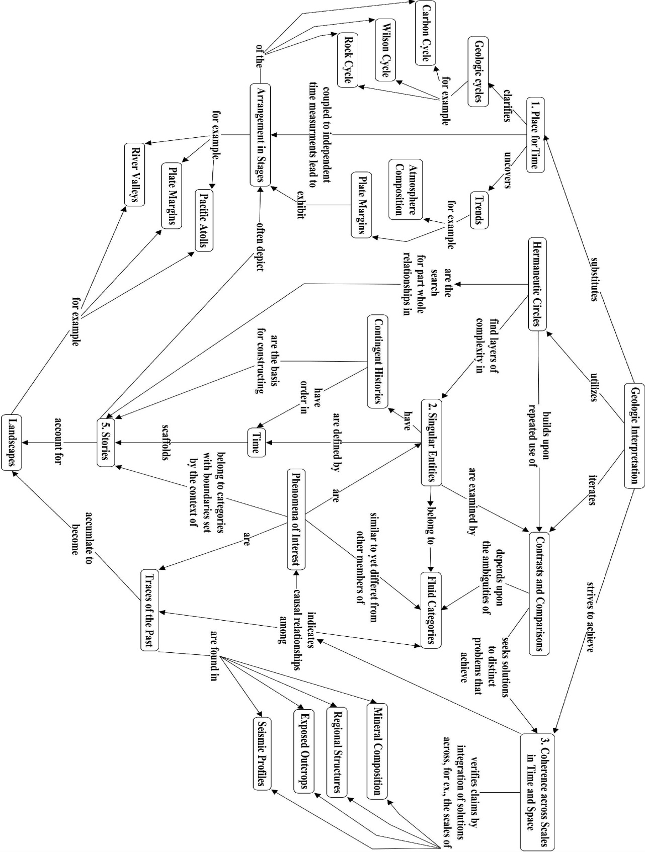
Meaningful learning requires making connections among concepts and from concepts to experiences. When structured around core concepts, these connections lead to disciplinary expertise and insight.

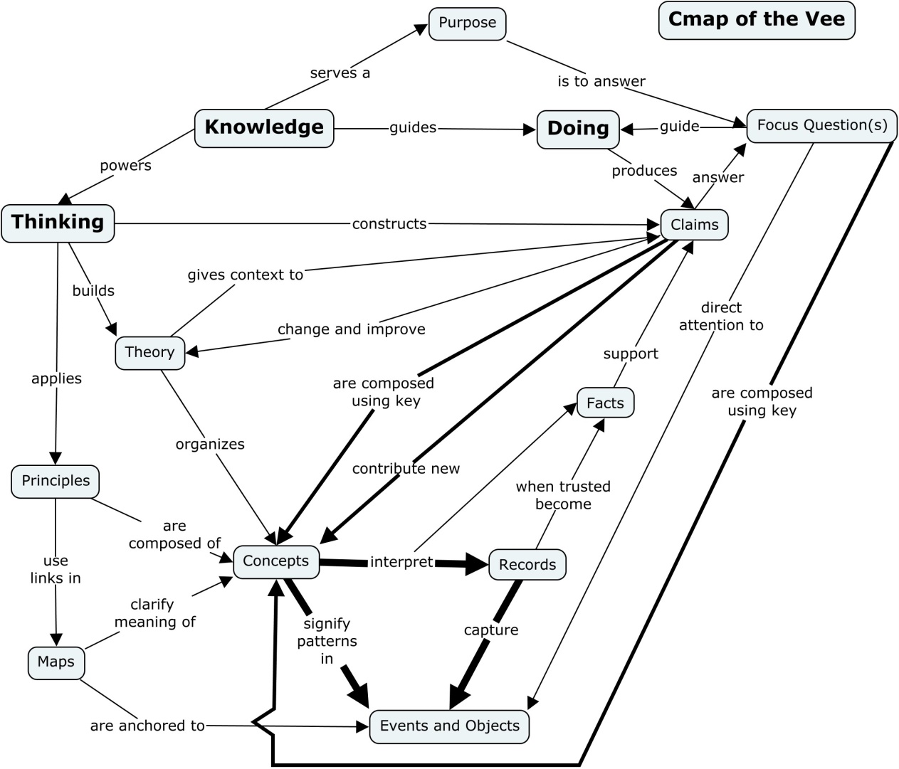
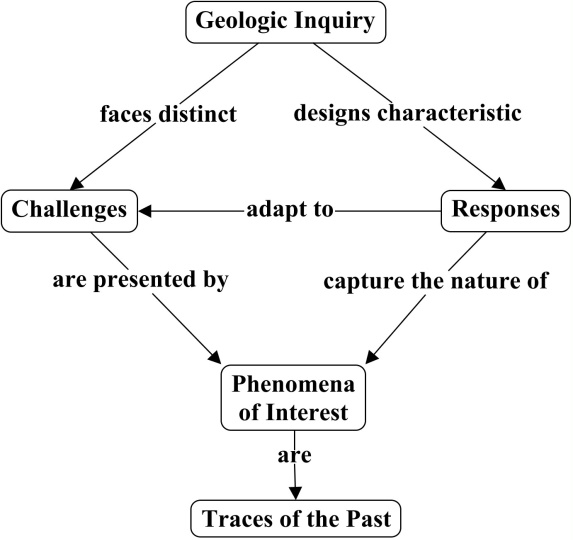
Habits of mind characteristic of different disciplines develop in response to distinct challenges. As a result the structures of knowledge differ from one field to another. Concept mapping and Vee diagramming promise to bring such structures into focus, making learning efficient. (Concept maps are drawings that depict networks of relationships and hierarchy among concepts. Vee diagrams deploy concept maps in order to represent the structure of knowledge in the context of an inquiry.)

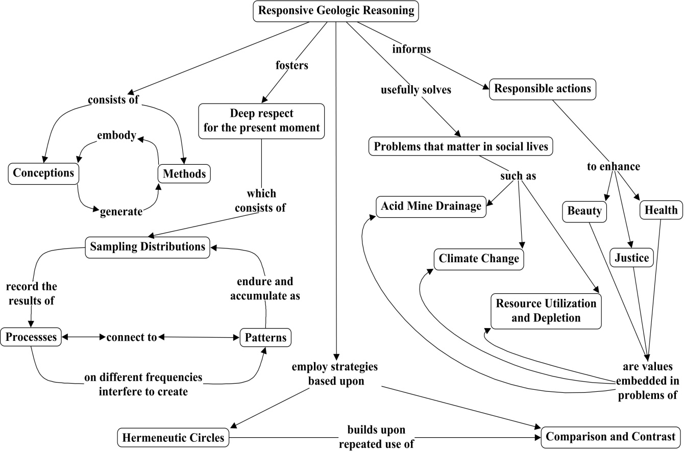
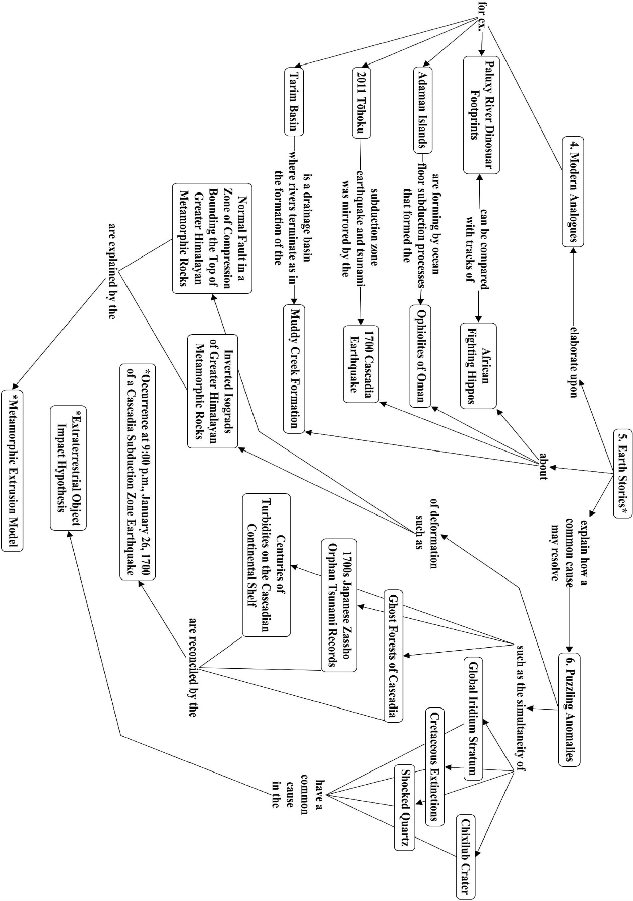
Geologic reasoning responds to challenges of scale and the contingent nature of historical phenomena. Often analogical approaches—comparison and contrast—play an important role in geologic inquiry.

Comparing one place to another, in terms of its geologic history and climate pattern, for example, has the potential to illuminate the “big picture” while fostering a “deep love” for knowledge. Geologic inquiry often depends on finding modern analogues for historical processes.

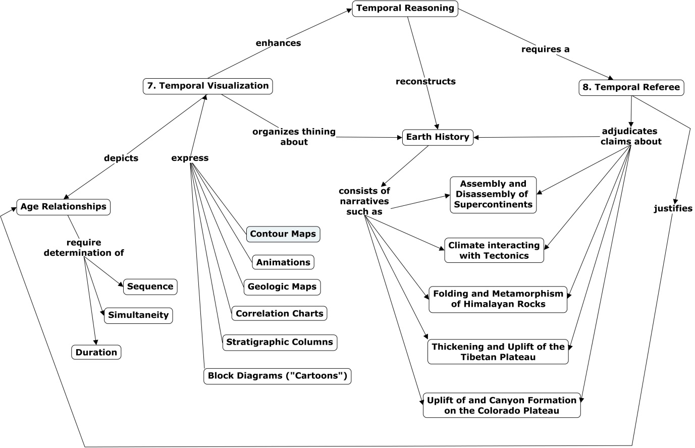
Plate tectonics theory and the geologic time scale are two “big ideas” essential to organizing meaningful understanding of geology. The former can be illustrated with attention to the patterns and processes characteristic of plate boundaries and collisions. The interpretation of the Grand Canyon of the Colorado River reveals the power of insight into deep time. Comparison and contrast of the geologic history of the Tibetan and Colorado Plateaus. understood in terms of plate tectonics, reveals principles for interpreting earth’s dynamic landscapes.

The Earth system—the atmosphere and oceans, the icecaps and glaciers, the soil and vegetation, and the animals and insects—is a complex, interacting system with both strong and delicate feedbacks that govern the climate and the habitability of our planet.
–Ian Roulstone & John Norbury, Invisible in the Storm (Princeton: 2010), pp.44-45

2. Prerequisites:

English proficiency.
Familiarity with geologic or geographic concepts at an introductory level.
Willingness to study original research in an unfamiliar discipline.
Curiosity about how landscapes form.

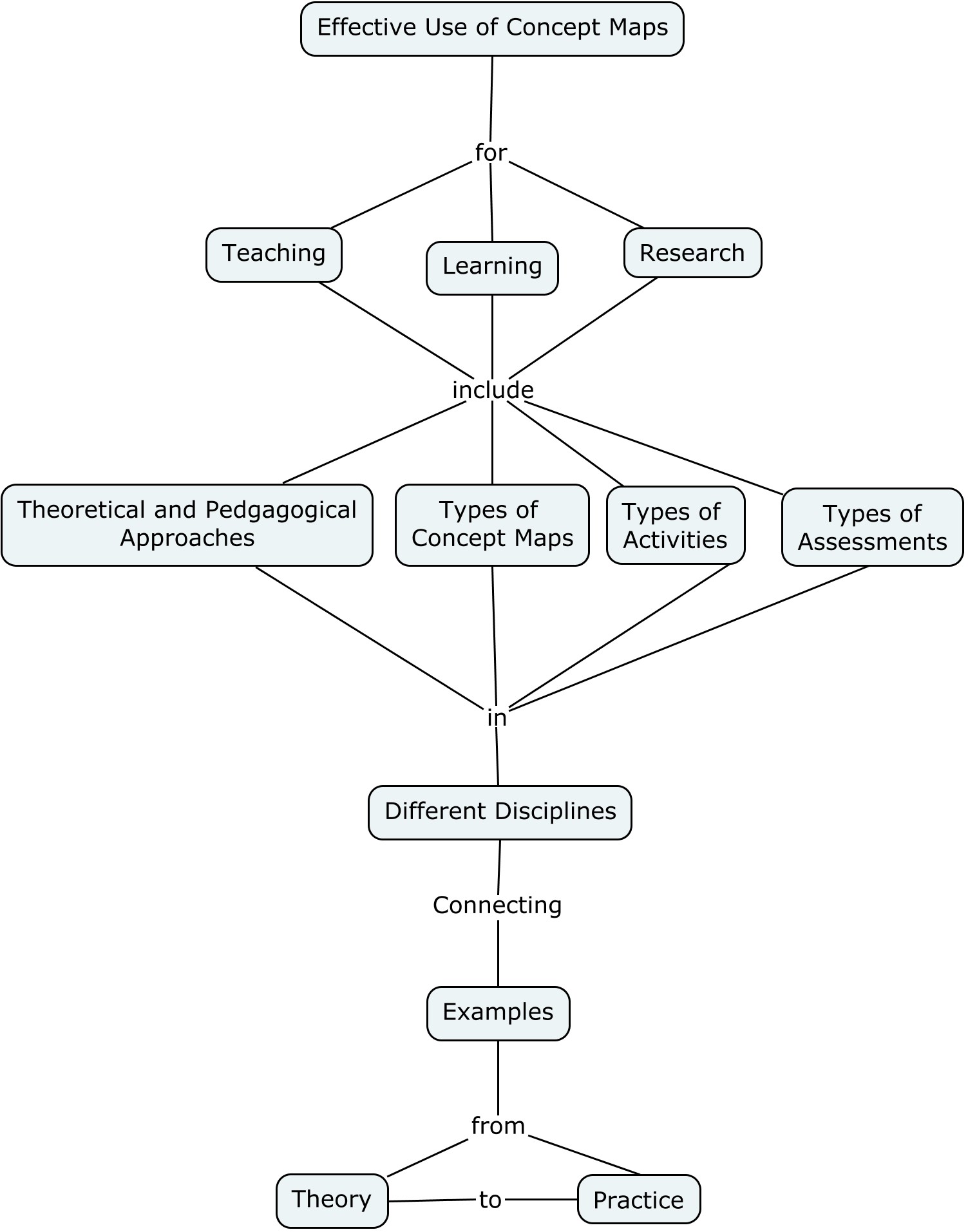
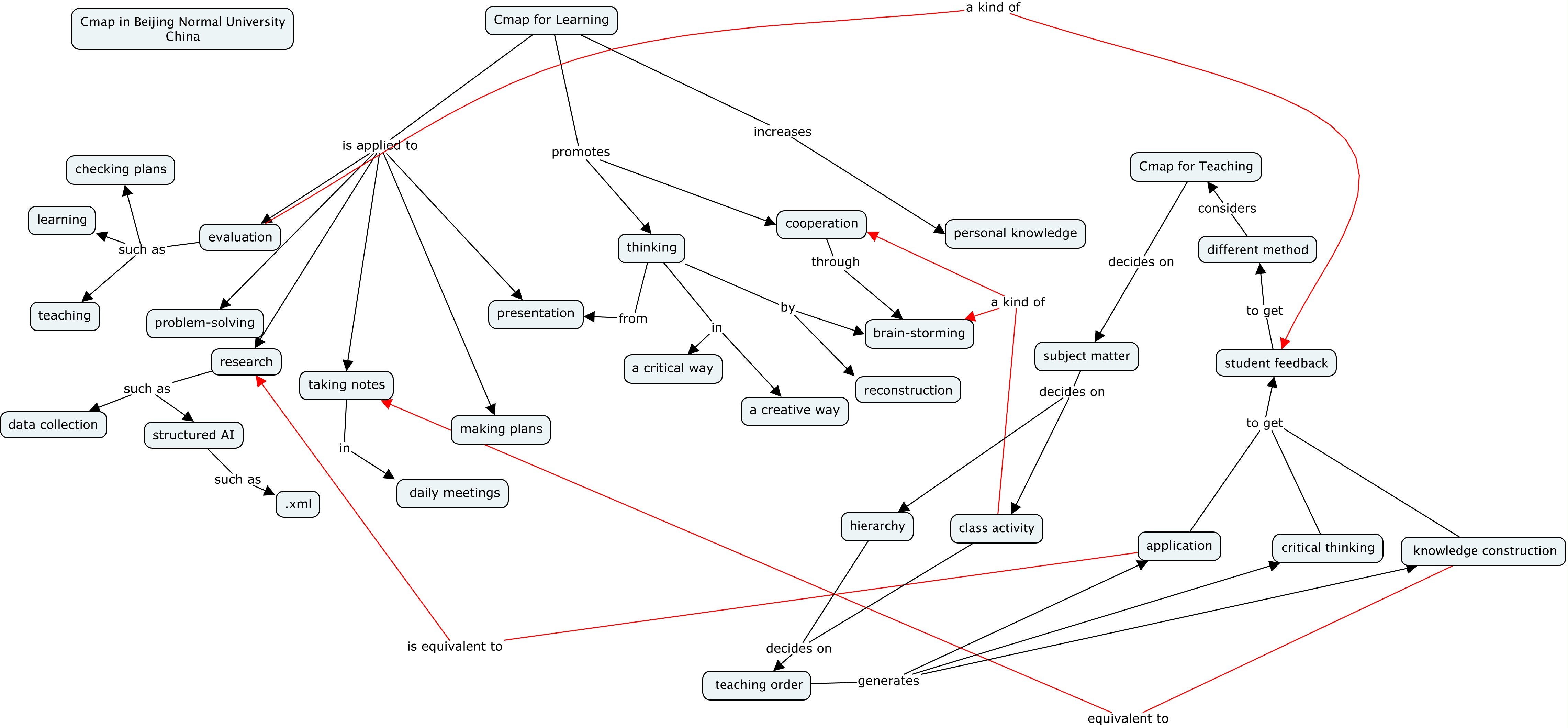
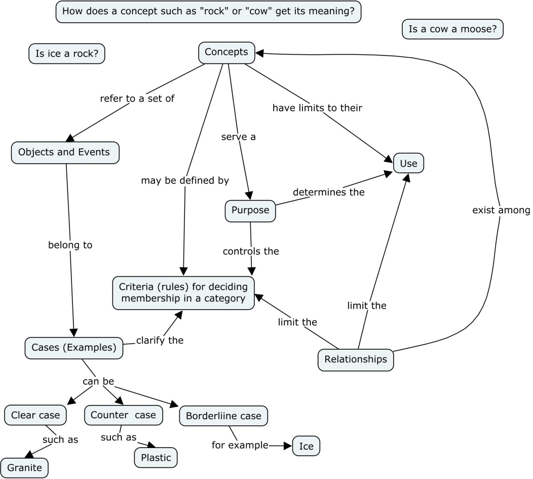
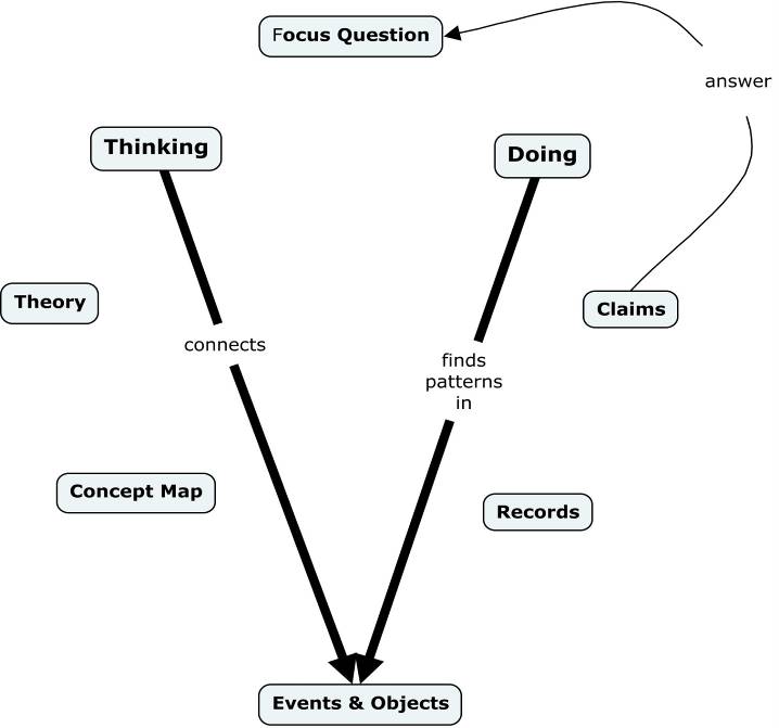
3. Concept Maps of Concept Meaning and Vee Diagrams (the “big picture”):

outline1

outline2

outline3

4a. Concept Maps of Topics:

outline5

outline4

outline9

outline6

outline7

outline8

4b Topics:

Concept Maps, Vee Diagrams, and Principles of Geologic Reasoning
Novak, J.D. (1990). Concept mapping and Vee diagrams: Two metacognitive tools to facilitate meaningful learning. Instructional Science, 19, 29-52.
Ault, C. (2015). Gowin’s Knowledge Vee Answers Five Questions about Inquiry. Notes for the BNU Cmap and Vee Diagram Workshop. Unpublished manuscript.
Ault, C. (2017). Thinking Geologic Thoughts: Responding To the Challenges Of Inquiry; 1st Asian Pacific Conference on Concept Mapping, September 20-22, 2017, Beijing Normal University.
Romey, W. D. (1983). Winter Ice and Snow as Models of Igneous Rock Formation. Journal of Geological Education , 31, 9-12.

Patterns of Plate Tectonics
Molnar, Pe. (2015). Plate Tectonics: A Very Short Introduction by Peter Molnar (Oxford, UK: Oxford University Press).

Cascadia Subduction Zone Processes
Ault, C. Review of The Orphan Tsunami of 1700. (2006). Prepared for the University of Washington Press.

Formation of the Grand Canyon of the Colorado River
Pederson, J. L. (2007). The Mystery of the Pre–Grand Canyon Colorado River—Results from the Muddy Creek Formation: GSA Today, v. 183, p. 4-10. doi: 10.1130/GSAT01803A.
Karlstrom, K., et al. (2012). Introduction: CRevolution 2: Origin and evolution of the Colorado River system II. Geosphere, 8, 1170–1176. doi:10.1130/GES00716.1
Lucchita, I., Holm, R.F., & Lucchitta, B.K. (2013). Implications of the Miocene (?) Crooked Ridge River of northern Arizona for the evolution of the Colorado River and Grand Canyon. Geosphere, 9, 1417–1433. doi:10.1130/GES00861.1

Causes and Consequences of Plateau Uplift (Tibet and Colorado)
Fillmore, R. 2011. Geological Evolution of the Colorado Plateau of Eastern Utah and Western Colorado. Salt Lake City, UT: University of Utah Press.
Fillmore, R. (2011), The Tertiary Period: The Rise of the Colorado Plateau, Geological Evolution of the Colorado Plateau of Eastern Utah and Western Colorado. Salt Lake City, UT: University of Utah Press.
Garzione, Carmala N. (2008). Surface uplift of Tibet and Cenozoic Global Cooling. Geology, 36(12), 1003-1004.doi: 10.1130/focus122008.1
Harrison, M.T., Copeland, P., Kidd, W. S. F., & Yin, An. (1991). Raising Tibet, Science 255, 1663-170. See also “A Quake-Causing Collision Course,” New York Times, May 19, 2015, p. D5.
Raymo, M.E., & Ruddiman, W.F. (1992). Tectonic forcing of late Cenozoic Climate. Nature, 359(6391), 117-122.
Ruddiman, W.F., & Kutzbach, J.E. (1991). Plateau Uplift and Climatic Change: The formation of giant plateaus in Tibet and the American West may explain why the earth’s climate has grown markedly cooler and more regionally diverse in the past 40 million years. Scientific American, 264(3), 66-75.
Searle, M. (2013). Roof of the World in Colliding Continents. Oxford, UK: Oxford University Press.
Searle, M. (2013). The Making of the Himalaya/Tibetan Plateau in Colliding Continents. Oxford, UK: Oxford University Press.

4c. Powerpoint resources:

ppt. 001, “Introduction and Analogy.”
ppt. 003, “Colorado Plateau and Plate Tectonics.”
ppt. 002 “Ghost Forests of Cascadia.”
ppt. 005 “Colliding Continents and Plate Driven Tectonics
ppt. 006 “Climate Change and Plateau Uplift
ppt. 009 “Grand Canyon and the Trail of Time

5. Course Arrangement:

  • Field Activity
  •      

    1. Interpreting the viewing stones of the BNU campus
    2. Ice and buoyancy exploration
    3. The rock cycle as displayed in the lobby of the Jingshi Hotel
  • Homework and Classroom Concept Mapping and Vee Diagramming Exercises
  •      

    1. What are the organizing concepts of plate tectonics?
    2. What caused the “Ghost Forests” near the coast in the Pacific Northwest (Cascadia)?
    3. How did the Colorado and Tibetan Plateaus form?
    4. When and how did the Colorado River carve the Grand Canyon?
    5. How are the weathering and uplift of Tibet related to climate change?
    6. Apply principles of geologic reasoning to examples of interpreting Cascadia, Tibet, and the Grand Canyon.

6a. Supporting References:

Blakey, Ron, & Ranney, Wayne. 2008. Ancient Landscapes of the Colorado Plateau. Grand Canyon, AZ: Grand Canyon Association.
Kearey, P. Klepeis, K. A., and Vine, F. J. 2009. Global Tectonics. West Sussex: Wiley-Blackwell.
Nie, J., Horton, B. K., and Hoke, G. D., Eds. 2014. Toward an Improved Understanding of Uplift Mechanisms and the Elevation History of the Tibetan Plateau (GSA Special Paper No. 507). Boulder, CO: Geological Society of America.
Searle, M. 2013. Colliding continents: A geological exploration of the Himalaya, Karakoram, and Tibet. Oxford University Press: Oxford, UK.

6b. Projects (3 maps, 1 vee):

1. Concept map: What are the key concepts of plate tectonics?
2. Concept map: How do rocks form?

3a. Concept map: Models of plateau uplift for Tibet and Colorado or
3b. Concept map: Tibetan plateau and climate change

4a. Vee diagram: Carving the Grand Canyon of the Colorado River or
4b. Vee diagram: Creating the Ghost Forest of Cascadia

6c. Expected hours of work:

Daily reading of Plate Tectonics text by Molnar and research articles for each topic (1-2 hours/day).
Concept map construction and revision daily both during the workshop and as homework working with partners (1-3 hours/day plus evening class).

《学会学习和思考之教育和教育研究》设计

按照Teach Less, Learn More课程体系的一般设计要求《学会学习和思考》的设计原则,我们做了《教育和教育研究》的设计。

Effective Use of Concept Maps for Teaching, Learning, and Research
Dr. Simone C. O. Conceição, Professor, University of Wisconsin-Milwaukee

Simone_Course

This module will introduce you to effective strategies for using concept maps for teaching, learning, and research. At the end of this module, you will will be able to use concept maps as an approach for teaching and learning in different disciplines; create a blueprint incorporating concept map as a learning strategy; identify ways for using concept maps as a research tool for data collection, analysis, and presentation; and develop a plan for using concept maps for conducting research.

This module will involve presentation of concepts and theories via lecture, group discussion, and individual and group practice using IHMC CmapTools Software.

This module will be taught in English. You will be expected to complete assignments in English.

It is expected that you will have some knowledge of the use of concept maps and skills on how to use IHMC CmapTools Software. Also, you will be expected to complete readings before attending sessions.

Module Outline

Simone_Course2

Day One

Introductions, Getting to Know Participants, Needs assessment, Scavenger Hunt, Pedagogical and Theoretical Approaches for Using Concept Maps, Types of Concept Maps, Learning strategies using concept maps

DAY Two

Learning strategies using concept maps in different disciplines

DAY Three

Teaching strategies using concept maps in different disciplines: activities

DAY Four

Teaching strategies using concept maps in different disciplines: assessments

DAY Five

Research strategies using concept maps: data collection and analysis

DAY Six
Research strategies using concept maps: data presentation

Learning Assessment
Students will be graded based on participation in course activities, course blueprint, module reflections, and final presentation.

References

Burke, J. G., O’Campo, P., Peak, G. L., Gielen, A. C., McDonnell, K. A., & Trochim, W. M. (2005). An introduction to concept mapping as a participatory public health research method. Qualitative Health Research, 15(10), 1392-1410.
Butler-Kisber, L., & Poldma, T. (2010). The Power of Visual Approaches in Qualitative Inquiry: The Use of Collage Making and Concept Mapping in Experiential Research. Journal of Research Practice, 6(2). Retrieved from http://jrp.icaap.org/index.php/jrp/article/view/197/196
Campbell, R., & Salem, D. A. (1999). Concept Mapping as a Feminist Research Method Examining the Community Response to Rape. Psychology of Women Quarterly, 23(1), 65-89.
Cañas, A. J., & Novak, J. D. (2006). Using concept maps to organize information for large-scale literature reviews and technical reports: two case studies.
Conceição, S. C. O., & Taylor, L. D. (2007). Using a constructivist approach with online concept maps: Relationship between theory and nursing education. Nursing Education Perspectives, 28(5), 268-75. National League for Nursing.
Conceição, S. C. O, Baldor, M. J. & Desnoyers, C. A. (2009). Factors influencing individual construction of knowledge in an online community of learning and inquiry using concept maps. In R. Marriott & P. Torres (Eds.) Handbook of Research on Collaborative Learning using Concept Mapping, 100-119. IGI Global.
Daley, B. J., Canas, A. J., & Stark, T. (2007). CmapTools: Integrating teaching, learning, and evaluation in online modules. New Directions for Adult and Continuing Education, 2007, 113, 37-47.
Daley, B. J., Conceição, S. C. O., Mina, L., Altman, B., Baldor, M.J., & Brown, J. (2010). Concept mapping: A strategy to support the development of practice, research, and theory within human resource development. Human Resource Development Review, XX(X), 1-28.
Hay, D. B. & Kinchin, E. M. (2006). Using concept maps to reveal conceptual typologies. Education & Training, 48 (2/3), 127-142.
Jackson, K. M., & Trochim, W. M. (2002). Concept mapping as an alternative approach for the analysis of open-ended survey responses. Organizational Research Methods, 5(4), 307-336.
Kinchin, I. M., Streatfield, D., & Hay, D. B. (2010). Using Concept Mapping to Enhance the Research Interview. International Journal of Qualitative Methods, 9(1).
Meagher-Stewart, D., Solberg, S. M., Warner, G., MacDonald, J., McPherson, C., & Seaman, P. (2012). Understanding the Role of Communities of Practice in Evidence-Informed Decision Making in Public Health. Qualitative Health Research, 20(10),1-17.
Morrison, D. (2006). Critical Thinking in a Collaborative Online Learning Environment. Advanced Technology for Learning, 3(4), 255-262.
Richardson, R. (2007). Using concept maps as a tool for cross-language relevance determination. (Order No. 3288675, Virginia Polytechnic Institute and State University). ProQuest Dissertations and Theses, 196. Retrieved from https://ezproxy.lib.uwm.edu/login?url=http://search.proquest.com/docview/304792723?accountid=15078. (304792723).
Trochim, W. K. Concept Mapping, available at http://www.socialresearchmethods.net/kb/conmap.htm
Trochim, W., & Kane, M. (2005). Concept mapping: an introduction to structured conceptualization in health care. International Journal for Quality in Health Care, 17(3), 187-191.
Wheeldon, J., & Faubert, J. (2009). Framing Experience: Concept Maps, Mind Maps, and Data Collection in Qualitative Research. International Journal of Qualitative Methods, 8(3).
Wheeldon, J. (2010). Mapping mixed methods research: Methods, measures, and meaning. Journal of Mixed Methods Research, 4(2), 87-102.
Wheeldon, J. (2011). Is a Picture Worth a Thousand Words? Using Mind Maps to Facilitate Participant Recall in Qualitative Research. Qualitative Report, 16(2), 509-522.

“Teach Less, Learn More”体系课程设计的学习材料

我打算找一找少数几个学科上有深刻理解,对教育有心的老师,来实现我提出的只关注学科大图景(学科的基本问题和典型思考方式),教给学生尽量少但是尽量深刻的内容和内容的理解和组织,教给学生学习方法,用自己对学科的热爱影响学生的,所谓的“Teach Less, Learn More”的体系。

下面是学习材料。我对参与这个项目的老师的要求和期待非常高。我希望靠这个来探索新的教学体系,改变中国的教育,走出培养创新性人才,有责任感的社会公民的道路。

读书报告需要包含概念地图和文字总结。内容上需要有总结,思考,和结合自身经验的体会,目的是反映:我读过,我想过,我有所得。可以参考这个例 子:读 《教育的目的》的体会

如果有兴趣,读一下《如何阅读一本书》(莫提默·艾德勒 / 查尔斯·范多伦 )、《教育的目的》(怀特海)这两本书。都可以从网上买到。顺便,如果你去下载一个读书人app,上面有我对这两本书还有我自己的《概念地图教学和学习方法》的介绍。除了怀特海,你还可以看看Kolmogorov认为“数学学什么教什么”

  1. 读吴金闪《概念地图教学和学习方法》。书看完之后需要做读书报告。
  2. 反映教学思想的Ted Talks整理(前12个必听,每一个15分钟左右。每一个听完之后,需要做概念地图并且用一句话总结主要内 容):http://www.systemsci.org/jinshanw/2016/01/05/jinshans-ted-talk- playlist-on-eudcation/
  3. 3、反映吴金闪的教学革命的理念的:关于学会学习和思考的对话为了理解世界而学习,为了发展自我而学习读 《How not to be wrong》:乘法表该教吗?什么是通识教育(Liberal Arts Education) 关于如何设计“Teach Less, Learn More”体系的课程的对话

  4. 我们的工作内容,Teach Less, Learn More体系下课程设计的例子:见《概念地图》书里面案例的章节,同时也可以在这里找到——“Teach Less, Learn More”课程设计举例:量子力学。这个体系的核心是要精简,教的少,教得深刻,有目的。关注学科基本问题和典型思考方式。对一门课程先解构到底(基本问题,基本概念,典型思维,逐步分解,一直追问为什么,联系是什么),然后,按照教的少,教得深刻有目的(目的围绕大图景)的方式重新建构这个学科的概念体系,并确定教什么怎么教。彻底解构和重构,关注联系,选择关键,这忽然让我意识到,其实这个概念地图教学法应该被称作“系统科学教学法”:彻底的还原论、完全的整体论、相互关系、关键因素。原来我提出和喜欢这个体系的深层次原因是我是一个研究系统科学的人。
  5. 工作方式和计划:理解这些教育理念和设计思想,具体我们可以进一步讨论,然后选择一门课程来做设计(目的、大图、教什么、怎么教、为什么这样 教、为什么教这些),然后做教学实验。教学可以结合项目为基础的教学,教学需要非常鼓励思考反问。其中,我和这个队伍中其他人的作用,在理念上你 可以找人讨论,在具体内容和思维方式的选择上,有一双双批判性的眼睛,其他经验的分享。
  6. 以后出公开课、视频课,出教学思想和教学设计案例,影响更多有才能有思想的老师来参与,转变更多一般的老师来做视频课程的教练。

刚才跟一位老师讨论,说起来这个系联性思考的思想有没有研究工作的例子。我把我们的这方面的两个已经完成的研究工作列在这里。其实,我的大多数研究,都采用的这个思想——事物之间的联系所导致的直接和间接的效果,用这样的方式来考察个体、个体周围乃至整体系统层面的一些问题,仅仅具体系统上发展起来的分析计算方法以及所面对的具体问题不一样而已。

  1. Input-output analysis and Scietometrics published by Journal of Informetrics.
  2. Network of Chinese characters and its implication to teaching and learning of Chinese characters, published by PLOS ONE, covered by a BBC story here

让我们一起来make a difference。